| T O P I C R E V I E W |
| momo |
Posted - January 06 2004 : 07:19:07 AM
Being new to the board, can I first say that in the time I have been looking in on some of the chat etc, that it has been some of the most informative material I have come across re. the subject of GAC and the Little Bighorn. Most interesting. Keep up the good work folks.
The question I want to ask of anyone who is interested, is what exactly is "the divide" Is it simply a trail between 2 valleys? A natural plateau formed between the outer valley ridges or what.
In all the material I have read, crossing "the divide" is mentioned regularly and as a matter of fact. However try as I might I can't quite pin down in my minds eye what the divide might actually consist of.
I am from Scotland and although we have some pretty rugged country over here, divide is not a term we would use in terms of describing the lie of the land.
Please forgive my ignorance on this but if anyone could help in providing a clearer picture of what constitutes "the divide" I would be most grateful. |
| 25 L A T E S T R E P L I E S (Newest First) |
| joe wiggs |
Posted - December 12 2009 : 9:07:25 PM
Sgt. Major, you and Brent are sorely missed. I hope my redundancy does not offend you but, I keep repeating myself hoping that you both will return. Benteen and I write of your spirit and �lan often. god bless you both. Frank we miss you as well and may God bless you too! |
| Sgtmajor109th |
Posted - July 14 2008 : 2:46:05 PM
Frank, I was doing some checking, while Custer moving along the trail
the burning Tepee was spotted. According to Sgt Kanipe in order to get
to the Tepee they had to find a crossing on the Creek,thus Custer was
on the south side of Reno when he was at the Tepee.
Now if you go to the mouth of South Fork creek and use google use the
ruler on path and move to 1,17 miles. You will come out close to where
you had shot your picture. Speaking of your picture, I had blown it up
larger to study it found that cattle were out grazing.
Now one other thing that may be helpful. Custer and Reno rode overs the
flats together, however when he made the split he recrossed Reno Creek
to make his crossing at the LBH. I don't know if you have ever been to
this site but if not check it out. It is Terraserver-USA. Much like
google, but no toys to play with. And its in black and white, however
you can get a great view of things, take a look at Ford "A" and you
can see why Reno had to make a crossing over Reno Creek.
Terraserver-usa.com/ Still working on the measurments, but check out
the one I had checked. |
| Sgtmajor109th |
Posted - July 14 2008 : 12:21:30 PM
Frank, there is another site I go to called TopoZone, which you have to
pay for, I can use the same methods as Google. But I can enter the Gps
locations and they will be marked by an x. Also has a ruler. |
| frankboddn |
Posted - July 14 2008 : 09:51:15 AM
Sgtmjr, I'd said somewhere that I wished google earth had a way to show distances, like they do coordinates and altitude. They do. Using Mike Fox's google and measuring from pin location to pin location as best I could, I came up with the following, that I know aren't pinpoint accurate, but approximate:
Divide to Ford A: 11.95 miles.
Divide to Tepee: 7.65.
Lone Tepee to Ford A: 4.51.
Again, I don't think these are totally accurate and are dependent on Fox's pins accuracy. But it's still fun to use it. |
| Sgtmajor109th |
Posted - July 13 2008 : 8:10:52 PM
Frank, I use Google Earth all the time, while in the service one of
my jobs was Air Intelligence, matching up photo's to what was on the
ground, I was doing that with your photo and I think I am getting close.
A Little more information for. My Gen. friend said that in the book he
had on "Search For The Lone Tepee" they put the distance from ford"A"
at about 31/2 miles to the Lone Tepee. It seems from the note's that Jim
Court had sent me, he was working with a Fox, don't mention which one. He
had some Camp note he was using to locate the Tepee area.
He says that Camp's 3.23 Mileage from ford "A" to the tepee based on a
ford to the southwest. He said that Camp had a distance of 1.17 miles from
the morass to the Lone Tepee, and the Lone Tepee 2.65 miles from Ford "A"
he said that this had fit well with Reno receiving orders when the Indians
were about 2 miles away. His total is 9.64 miles from the divide to the
Tepee. Camp had a total of 12.87 miles from the divide to Ford "A" while
Court and Fox came up with 12.29 miles.
By the way, I will buy the beer, at the end of the month when I go to the
War Room, Iam going to show your pictures, when we have the happy hour we
will all toast you with a beer, except the General he drinks wine. |
| frankboddn |
Posted - July 13 2008 : 7:19:23 PM
Sgt.Mjr., I just went to Google Earth, Mike Fox's, and checked the coordinates for Ford A and they're pretty much exactly where Court told you. If you go to Google Earth and get the aerial view, you can see Reno Creek Road and how far away it is from Ford A and see you can't really see it from the road. I was surprised how close it is, though, to the Bird In Grounds' property at Reno Crossing. You can also see how close it is to Lone Tepee. The area between the road and lone tepee is all open, no trees to block your vision, so it's easy to see. Again, no one knows the lone tepee's exact location, but the area is pretty close. In case you didn't have the google earth site, here it is. It's very interesting and a great tool:
http://homepage.ntlworld.com/adam.fox57/MikeFox/LBH/LBH
Click on the link that tells you to download it. Let me know what you think of it. |
| frankboddn |
Posted - July 13 2008 : 7:09:28 PM
Sarge, when I took the picture of the Lone Tepee area, I was standing on Reno Creek Road. Also, Reno Creek road more or less splits, runs right over the morass. Please feel free to use any pictures I post in any way you wish. If you make any money off of them, I want a steak dinner and a couple beers.
Ford A? Not sure how much help I can be there. I remember when we were on Reno Creek Road, someone pointed in the general direction, but don't know if we could see it. The ebst picture I've seen of it is the one in "Where Custer Fell" I mentioned earlier from Dennis Fox. I'm wondering if Mike Fox's GOogle Earth where he put "pins" on the map would show it. I'll take a look.
Frank |
| Sgtmajor109th |
Posted - July 13 2008 : 2:10:01 PM
Frank, another question for you, when you took the picture of the Lone
Tepee area, were you in the area of Reno Creek Rd. and what direction
were you looking when you took the picture. And about how far were you
from the crossing of Ford "A". |
| Sgtmajor109th |
Posted - July 13 2008 : 12:55:17 PM
Frank and Joe. We have a great time at our gatheringsd, however if you think
things get heated around here at times, you should be with us. Frank your
piture of the Lone Tepee area was great. I made a copy for my files, hope
you don't mind. I am posting the GPS for the Ford "A" area. Check it out let
me know what you think. This also sent to me by Jim Court.
Ford "A" 45'30.271N 107.22.627W He also wrote me that the GPS fits the
description in the sources, didn't say what they were. It is where the bluffs
come down to the creek bed with a knoll about 50 feet high, and just east of
it is Girard's Knoll. He also said that the Lone Tepee was located in the
vicinity of the landing field. Frank, does this fit into what you had seen
at the area. And you can see a landing field on topo maps. |
| frankboddn |
Posted - July 12 2008 : 02:31:04 AM
Joe, if you can get your hands on "Where Custer Fell," it's the greatest book I've seen of vintage pictures all over the battlefield alongside modern pictures. If you find the book, look at Page 35. There is a picture taken in 1970 that was purchased by Dennis Fox from a book store in Billings showing what is supposed to be Ford A where Reno made his first crossing. Below this 1970 picture is one taken in 2001
If you don't have this book, I'd sure order one from Barnes & Nobel or maybe Friends of the LBH. It's by James S. Brust, Brian Pohanka and Sandy Barnard. Well worth the money. |
| joe wiggs |
Posted - July 11 2008 : 8:58:14 PM
Sgt. major, Please keep me posted. Like Frank, there's nothing like this in southern Oklahoma.
Frank, i hope you find that picture of Ford "A". I would love to see it. Yes Frank, your photo of the "Lone Tepee" came out great!!! |
| frankboddn |
Posted - July 10 2008 : 11:31:36 AM
http://i63.photobucket.com/albums/h153/bubbabod/PerrysmineLBHFoxtour2004LBHA2005242.jpg
SgtMjr, I hope this comes out. This is taken from Reno Creek Road and shows the area of the Lone Tepee. |
| frankboddn |
Posted - July 10 2008 : 11:25:22 AM
Sgt.Mjr, sure, please keep me posted. That must be nice to have a local group to meet with. Nothing like that that I'm aware of here in the San Diego area.
As for the exact location of the Lone Tepee, it really isn't known. Just the general location. I've been to the area a couple times with Dr. Rich Fox, and he and his brother, Dennis, pointed to the general area. I'm sure this is what Court is talking about. Somewhere, in one of my books, there is a very old post card courtesy of Dennis Fox that shows what is purported to be Ford A. I'll see if I can find it. MIght be "Where Custer Fell." |
| Sgtmajor109th |
Posted - July 10 2008 : 10:49:36 AM
Frank,and Joe. We have what we call a "War Discussion Group" that meets
the last friday of every month at the local armory. We were talking about
the LBH and I was explaining my thoughts about Benteens movements My good
friend a retired general who is into the Indian wars told me about the
site at the Army Combat Center, I checked it out and was surprised to
find it showed on the map the movements, I thought that Benteen made.
Also Frank, when Jim Court had sent me the cordinates for the Crow's
Nest, he also encluded the cordinates for the Lone Tepee and for Ford "A"
the Lone Tepee is also not located were Gray said it was. Also my Gen
friend says he has a rare book that was written by "Meketa and Bookwalter"
it is titled "The Search For The Lone Tepee. I will keep you posted. If
you would like the cordinates for the Tepee and ford "A" I would be
happy to post them for you. Good to talk to you guys again.
|
| frankboddn |
Posted - July 09 2008 : 11:34:41 PM
Sgt.Mjr, I actually have that site, but it's buried with other Indian War-related sites, I'd forgotten it. Thanks a lot. It's a great site.
I think Mike Fox's Google Earth with LBH "pins" is so helpful. I zoomed in to Court's coordinates for the Crow's Nest, and he was right-on. |
| joe wiggs |
Posted - July 09 2008 : 8:56:26 PM
Frank, you are the Man!!! Sgt. Major it is so good to hear from you as well! Both sites are fantastic! |
| Sgtmajor109th |
Posted - July 09 2008 : 8:22:58 PM
Frank, Great information had no problems with the sight. I was greatly
interested where Gibson had reached on the ridge. I have been studying
Benteen's movements for over a year now. I don't believe he came
back onto Custer's trail where Gray show's him on his map in his book
"The Sioux War of 1876". I believe he moved to the trail from the east
side of "South Fork Creek". Also have you seen the maps put out by the
Combat Army Center.
http://www.cgsc.army.mil/carl/Resources/csi/sioux/sioux.asp |
| frankboddn |
Posted - July 08 2008 : 9:02:37 PM
Sgt.Major and Joe, Sgt.Major had posted last year the GPS coordinates for the Crow's Nest provided to him by Jim Court. Since this sort of follows along with the whole subject of the divide, the crow's nest and all those points along Custer's trail, here is a Google Earth site, credit to Mike Fox, where Fox (Not Dr. Rich Fox) posted on this google earth the coordinates for the places of interest to those of us who study the subject. Click on the link and then go down to the kind of purpleish link to download it. It's a great site. I've also put in some "pins" showing other things, such as the Dull Knife battle, Reynolds' Powder river Fight. Crazy woman crossing. Let me know if you have trouble getting the site up or navigating it:
http://homepage.ntlworld.com/adam.fox57/MikeFox/LBH/LBH |
| joe wiggs |
Posted - June 27 2008 : 8:44:44 PM
It is such a treat to see an actual picture of the places we discuss here on the forum. Pictures help us to focus on the realities of the actual grounds covered by the participants of the battle and, augment our imaginations regarding the individuals whom walked upon these lands. Thanks so much. |
| frankboddn |
Posted - August 11 2007 : 12:41:17 AM
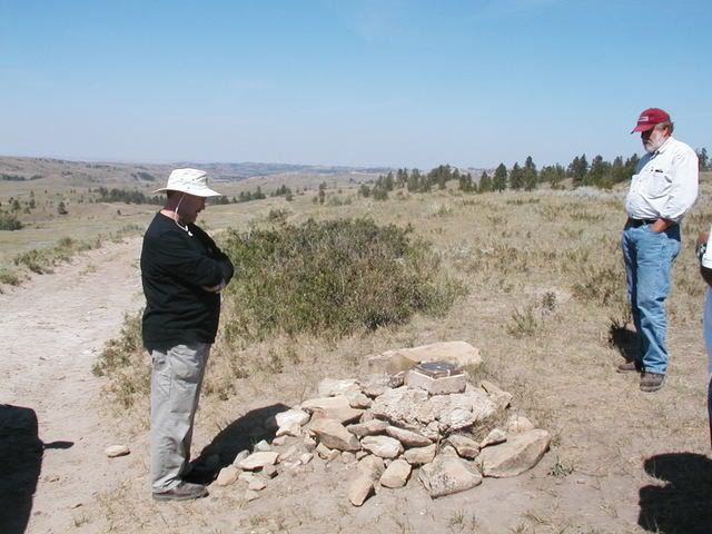
Joseph, I guess I should have added, for what it's worth, that from where this picture is taken, it is looking west if you continue down the road. The crow's nest is located back the other way, east, and south from this picture. If Perry were to turn around, he'd be looking at the Wolf Mountains and the Crow's Nest. Custer would have come basically from the opposite way the picture is taken, or from the east. |
| joseph wiggs |
Posted - August 08 2007 : 8:54:26 PM
Frankbodden,
Thank you, thank you, thank you. One picture is truly worth a thousand words. I will always be indebted to you for this wonderful illustration of the "Divide." |
| frankboddn |
Posted - August 08 2007 : 02:22:22 AM
Momo, this is the area of the divide. Perry Baker and Dr. Rich Fox at the divide marker:
 |
| AZ Ranger |
Posted - July 01 2007 : 10:23:54 AM
Thanks Sgt. Major |
| Sgtmajor109th |
Posted - June 28 2007 : 11:15:08 AM
GPS for the Crow's Nest. Very kindly sent to me by Jim Court who is now a retired guide at the battlefield.
Crow's Nest. N25'26'811' W107.09.399' |
| AZ Ranger |
Posted - March 25 2007 : 4:30:27 PM
Your welcome |
|
|

