|
MENUS! STOREFRONTS!
Guide book STILL Available - Free Downloads Only! In COLOR! |
|
|
The River Walk
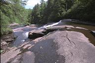
(refer to pages 18 &19 in On the Trail of the Last of the Mohicans) Triple and Bridal Veil Falls in Dupont State Forest .... Transylvania County
The final piece of the puzzle alluded to earlier were the four falls found at this location. Oh, I knew well enough where they were, courtesy of locations scouts, but would I be able to get photos of them for the booklet? You know the answer if you’ve seen the guide book, for they are in there, thankfully, but, this was the one single location I could not even publicly identify at the time On the Trail of the Last of the Mohicans was released. Not only can we now identify this locale, but we can invite you to go visit, for it is now public land. The story, as I wrote it for our Web Site some time ago:
~~~~~~~ The hustle & bustle of nearly six months of filming ... including pre-production ... in the normally still western North Carolina mountains was long gone. Nowhere to be found where the trailers & stars; the cameras & lights ... Fort William Henry was but a rubble now. Even the film, the finished product, had come through the area ... and was gone! But our sojourn was just beginning! As the film made its appearance on video, in March 1993, about six months after its theatrical release, our quest to determine the exact location of each & every scene that appears on film was initiated. During that summer of '93, we were able to fairly well document all the scenes. One place, though we knew where it was, remained elusive, much to our chagrin! This, of course, was the little two mile stretch of river, The Little River ... straddling the county lines of Henderson & Transylvania ... that featured four absolutely gorgeous waterfalls, each unique from the others, that was then owned by the Dupont Corporation. Though I pleaded ... and begged ... & groveled ... they refused me permission to enter the grounds and photograph the Falls! I had tried every trick in the book, all to no avail. The book would have to be presented without these scenes. Well, hold on! Something I said must have made sense, and several months later, after we'd given up all hope, THEY called US and asked if we were still interested. "But, of COURSE!!!" And off we went to photograph the Falls at last! This was February '94. Accompanied by a Dupont guide, I was allowed 2 visits. One then, in February, a kind of scout, and then another, later in the Spring, when full foliage adorned the area. Originally, their logic had been that they did not want to encourage visitors to the Falls. Now, though, after reconsidering, they had decided the booklet would make nice "favors" for their business associates. Thus, permission came about ... with 2 conditions: I could not actually divulge the location in print and I had to donate several copies of the finished product. No problem! I had the cherished photos! Dupont sold the property a couple of years later to Sterling Diagnostic Imaging who continued the trend of maintaining the Falls with nicely marked trails, picnic pavilions, and a sense of preservation ... all for the benefit of company employees & their guests. It was at this time that we made arrangements to include The River Walk as a part of our 1999 Great Mohican Gathering. Sterling welcomed us with open arms, even offering us free box lunches as part of the deal! It was sometime after this that Sterling sold out to AGFA who decided to sell off a huge tract of the property, including all four waterfalls, placing our little visit in serious jeopardy! Luckily, for us, a local land trust, comprised largely of Sterling employees, was holding the property until a suitable buyer could be found - gone were the lunches, but our visit was salvaged! - luckily for EVERYONE, one of the four falls, Hooker Mills, was bought by the newly formed Dupont State Forest. At least one of these four was now accessible to all! Just after The Gathering of 1999, the remaining property was sold to developer, Jim Anthony. High Falls, Triple Falls, & Bridal Veil Falls were now in serious danger ... not only of inaccessibility, but more importantly, of destruction! All the sordid details of the bidding process & double-talk can best be told by others. Suffice it to say, Mr. Anthony reneged on his word to make the falls accessible & minimize development. The State of North Carolina, an original bidder on the property, in the hopes of adding it to the State Forest system, has had its interest rekindled. A fight is on ... the moment of truth, barring any more delays, is at hand. Sometime between now & the not-too-distant future, the fate of the Falls will be decided. ~~~~~~~
The moment of truth has come and gone and we are happy to tell you that the State of North Carolina is now the owner of this bit of property, incorporating it into the 10,000 acre Dupont State Forest. Fate, this time, was most definitely on our side, and on that of the Falls. So, how does one get to this scenic locale? Thought you’d never ask! Thought I’d never get to tell you! ... from Chimney Rock Village ... take 64 west to Hendersonville. Make a left on Church Street in downtown. Go 6-8 blocks & make a right on Kanuga Street (which, in turn, becomes Kanuga ROAD outside of town, and finally Crab Creek Road - don't ask me why they constantly change names, it's NC!) Travel 4 or 5 miles, then another mile & a half past the Holmes State Forest sign on the left. Make a left on Dupont Road (which then becomes Staton Road) Hooker Falls parking lot is about 3.1 miles ahead, on the right, just before the bridge.
Drive to the new Hooker Falls parking lot on Staton Road (called Dupont Road in Henderson County). Cross over Staton Road, carefully watching for traffic. Walk along shoulder of road towards bridge and cross bridge. Find stepping stones and descend to the Little River on the opposite side of the bridge from parking area. Find the trail running parallel to the river and hike upstream about 1000' on level ground. Trail then bends to the right and ascends another 1000' feet up a steep slope. Find view of Triple Falls on your left. There is a trail down to the falls further up on the left. If continuing to High Falls, continue up the same trail until it ends at an intersection. Take the left turn and walk about 2000' parallel to the Little River. Turn right at the next intersection, and follow the trail up a moderately steep slope (about 900') to views of High Falls. There is a trail to the bottom of the falls further up on the left (warning: slippery rocks!). Also, steps to the right take you to the High Falls shelter, with excellent views. Finally, the last of the 4 to actually open to the public, Bridal Veil Falls.
From the High Falls Bridge (about 1.5 miles to Falls) From High Falls: Access the High Falls Bridge by continuing past the overlook on High Falls Trail until it intersects Pipeline Trail. Bear left and continue until it intersects with Conservation Road right at the High Falls Bridge. A more direct, though less scenic alternative would be to begin at the Main Gate on Staton Rd. and take Conservation Road directly to High Falls Bridge. Cross over the High Falls Bridge, and bear right to continue on Conservation Road. Continue parallel to the Little River until it crosses over the Reasonover Creek spillway below Lake Julia Dam. Once past the openings below the dam, take Bridal Veil Road on your right. Continue on Bridal Veil Road until it terminates near the base of the Falls. From Reasonover Road (nearly 2 miles to Falls) Park at the gated entrance on Reasonover Rd. which is just underneath the power lines. Take Conservation Road north until it reaches the airport runway. Continue on Conservation Road parallel to runway and as it bears right down the grade toward Lake Julia. After passing the horse barn on left, take Bridal Veil Road on left until it terminates near base of falls. It should be noted that the Forest, being young as a part of the State Forest System, has ongoing trail management. Some of these directions may change in the future, but, at last, you can now find your way there! Friends of the Falls, a conservation group instrumental in the movement to enter these lands into the public trust, maintain an excellent web site where you may obtain updates, at: http://www.dupontforest.com/ One other thing, Triple and Bridal Veil Falls (in that order) make up the River Walk; the other two, Hooker and High Falls, are seen in other portions of the movie, Canoes & Rescue, respectively. Bridal Veil also makes another appearance, at the Under the Falls segment. ~~~~~~~ Dupont State Forest is open to the general public year round.
All these falls are now freely accessible. Lovely picnicking facilities are
available overlooking both High and Triple Falls. ~~~~~~~ or |
|
|


 A short trail takes you right to Hooker Falls, the first of the 4 to make the
State Forest. To get to Triple and High Falls:
A short trail takes you right to Hooker Falls, the first of the 4 to make the
State Forest. To get to Triple and High Falls: