![The Mohican Board! [Bumppo's Redux!]](images/wwwboard.gif "The Mohican Board! [Bumppo's Redux!]") |
|
| Author |
 Topic Topic  |
|
|
James N.
Colonial Militia


USA

Bumppo's Patron since [at least]:
October 24 2007
Status: offline
|
 Posted - January 08 2013 : 8:49:22 PM Posted - January 08 2013 : 8:49:22 PM


|
...is that for most of its active career, it was pointing in the WRONG direction! I will assume most-if-not-all the readers of this forum are more-or-less familliar ( some intimately so ) with the old stone bastion originally known ( and still to Fitzhugh Williams! ) as Fort Carillon, so I do not intend to recount in detail its brief role in the French and Indian War. It is as a patriot post during the American Revolution that I would like to draw your attention; but first at least a little about its construction and early history is in order.
Image Insert:
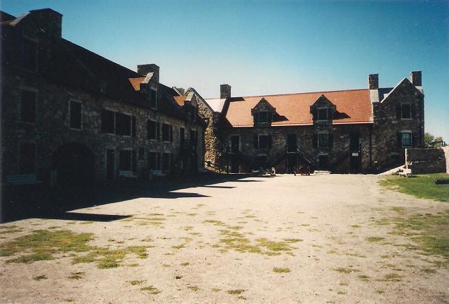
46.2 KB
Interior of Fort Carillon/Ticonderoga showing stone buildings grouped around the parade ground.
Built by the French as an outpost for Ft. St. Frederic at Crown Point, Carillon was placed on a bluff overlooking the length of a relatively narrow stretch of Lake Champlain, in the manner of the naval tactic called crossing the "T", whereby guns can be brought to bear at the head of a single ship, or down a line of ships. From this position, the advancing ships could not bring their broadsides to bear in order to return fire and were therefore relatively helpless. Unfortunately, as things worked out, this proved to be of little use in the life of the fort for several reasons, the first of which was that the engineer who planned the fort placed it a little too far back on its bluff for cannon to be brought to bear from the fort itself! That necessitated building the first of many outworks here, a lake-level earthen battery below the fort itself. When the British determined to eliminate Fort Carillon, they came by way of Lake George instead, so the fort's guns remained silent.
Image Insert:
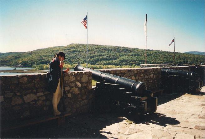
43.88 KB
The guns of Ticonderoga look impressive, but would be unable to actually hit anything in the lake at a range close enough to inflict much damage; note park interpreter in Continental uniform.
That brings us to another related problem: as a mere outpost Carillon was adequate, but when in the summer of 1758 the Marquis Montcalm decided to position most of his troops here, the fort was far too tiny to hold the over 4,000 men. Rather than fight the battle here, Montcalm selected a level plain a mile to the west where he built a wall of logs behind which his troops slaughtered the advancing redcoats and their colonial allies, led by Britian's argueably worst general, James Abercrombie. Two years later when the British returned, now led by the competent Jeffrey Amherst, the small French garrison withdrew to Fort St. Frederic without a fight.
Image Insert:
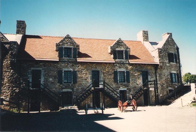
52.32 KB
Here on the stair landing of this building that served as both British officers' quarters and post headquarters occurred the most famous event in the fort's history, when in the pre-dawn of May 10, 1775, Ethan Allen and Benedict Arnold demanded its surrender, Allen calling out to the commandant, "Come out you damned old rat!"
Following the retreat of the French to Canada, the now-renamed British Fort Ticonderoga slipped into a sleepy obscurity, replaced in importance by the large and newly-built Fort Amherst at Crown Point. Manned by only a token garrison, the fort's main importance lay in its still-impressive collection of artillery. As recounted above, when the Revolution broke out, both Massachusetts and Connecticut recognized its importance, sending Benedict Arnold to secure the post, which he did by using Ethan Allen's Green Mountain Boys. Thus began a period of several contentious years in which Ticonderoga returned to prominence, not for the old stone French fort, but for its geographical location.
Image Insert:

50.87 KB
Note especially the eminence on the horizon known variously as Mount Defiance or "Rattlesnake Mountain"!
The artillery pieces assumed a renewed interest in the winter of 1775 - 76 when Henry Knox journeyed here at the behest of George Washington to bring them overland in what Knox called "A Noble Train of Artillery" to help break the Siege of Boston. Ticonderoga also served as a staging point for the later invasion of Canada, as well as a rallying point for the expedition's inglorious return. But it is possibly most important for its role in Burgoyne's ill-fated Saratoga Campaign.
|
|
report to moderator
|
|
|
Fitzhugh Williams
Mohicanland Statesman

Bumppo's Patron since [at least]:
July 17 2005
Status: offline
|
Posted - January 09 2013 : 08:49:17 AM

|
quote:
Originally posted by James N.
When the British determined to eliminate Fort Carillon, they came by way of Lake George instead, so the fort's guns remained silent.
Actually they did fire a little. When the British arrived, some of the milice saw the enormous army and decided it was time to head back to Canada. When they ran for the boats, the fort's cannon fired on them to help change their minds!
Note that some of the drawings of the battle show Montcalm standing beside a cannon. No cannon were on the line of wooden logs. |

"Les deux pieds contre la muraille et la tete sous le robinet" |
report to moderator  |
|
|
James N.
Colonial Militia
USA
Bumppo's Patron since [at least]:
October 24 2007
Status: offline
|
Posted - January 09 2013 : 11:46:18 AM
|
Image Insert:
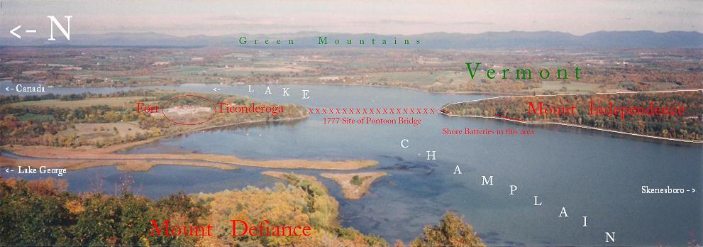
59KB
"I have beat them! I have beat all the Americans!"
- King George III on learning of Fort Ticonderoga's capture
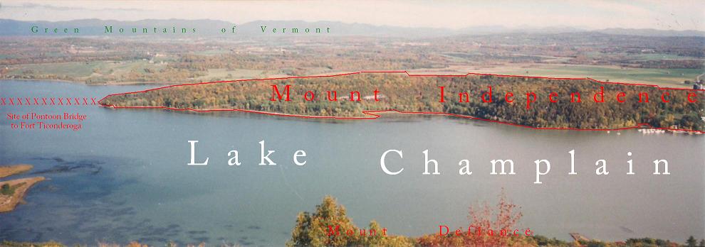
By 1777 Fort Ticonderoga had assumed an undeserved reputation as a strategic Gibralter, less for the little fort that now is all that remains, than for the immense installation it had become that was to bedevil its commander, the hapless Maj. Gen. Arthur St. Clair ( pronounced "Sinclair" ) and its loss would largely wreck his reputation. A look at the above photo will help to understand his particular problem trying to defend the sprawling area with only 2,500 men. There are three elements to consider: the narrow valley of the Lake George Outlet and the land surrounding it, including the site of the fort itself to the left; the relatively low-lying but immense "island" at the right known misleadlingly as Mount Independence, connected to the fort by a floating bridge and boom; and the height in the foreground from which the photo was taken, Mount Defiance ( "Rattlesnake Mountain" to the French ), which dominates the entire landscape.
Image Insert:
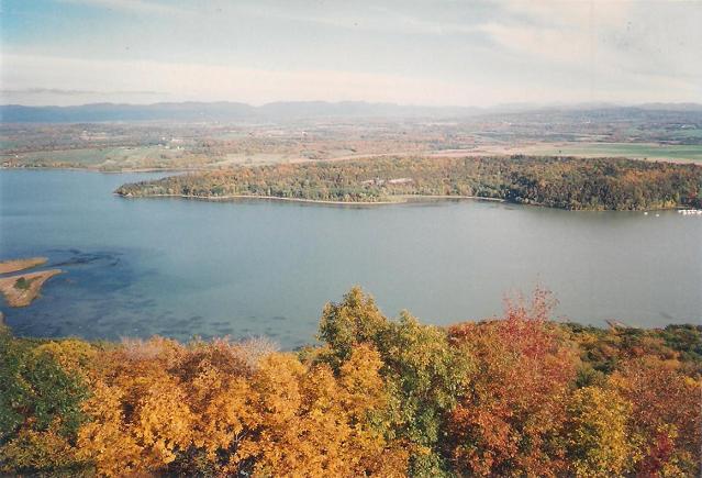
55.11KB
Another view from the summit of Mount Defiance across Lake Champlain towards the long, low mass of Mount Independence.
As previously noted, the actual fort was built to confront an enemy approaching from the south along Lake Champlain itself; there was virtually NO natural obstacle to a northern approach in the direction of Canada from which Burgoyne's force came with as many as 8,000 men. Mount Independence was supposed to confront this threat with water-level batteries built on its northern point facing up the lake. By this time it had been largely denuded of trees to support the earthen fortifications as well as build numerous barracks, supply warehouses, hospitals, and the like; at various times this was the numerically strongest post in the entire United States! Unfortunately, however, that also meant it was rife with camp diseases turing it into a virtual pest-hole, especially after the defeated and demoralized Canada army returned in 1776.
Image Insert:
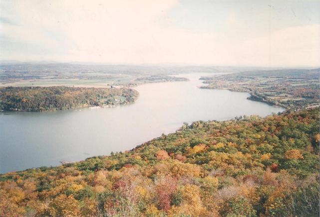
50.38KB
Looking south from Mount Defiance down Lake Champlain in the direction of Skenesboro ( now Whitehall ), N.Y.; it was in Skenesboro that former sea-captain Benedict Arnold oversaw the building of the little fleet with which he unsucessfully challenged the British at Valcour Island Oct. 11, 1776, but the tiny ships were actually completed and rigged out here at the wharves that once lined the shore of Mount Independence.
Mount Independence quickly became the main installation of this entire area, still known colloquially as Ticonderoga. Unfortunately for Arthur St. Clair, few in Congress realized its inherent weakness outside of Benjamin Franklin and John Adams who had visited here personally on an inspection trip and were now otherwise engaged, Franklin already in France. Due to its reputation stemming from Montcalm's successful defense and Abercrombie's unmitigated disaster in the previous war, it was thought both here and abroad that "Ticonderoga" was impregnable. But as has been shown, Montcalm had defended it at some distance from the fort, and his once-strong wooden wall had collapsed in the interviening twenty years! In that direction, St. Clair had begun a system of trenches and covering strongpoints like Mount Hope, another deceptive name for a hilltop wood-and-earthen fort in the valley of the "carrying place" between Lakes George and Champlain. This meant his meager brigade-sized force had to attempt to cover several miles of unfinished works both here and on Mount Independence from an attacking force at least three times his number that could land anywhere along the Champlain shore on either side of the lake above his position!
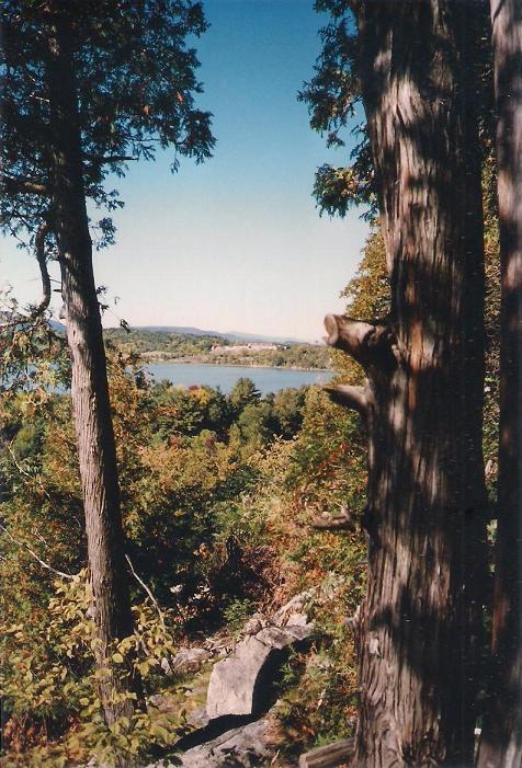
Image Insert:
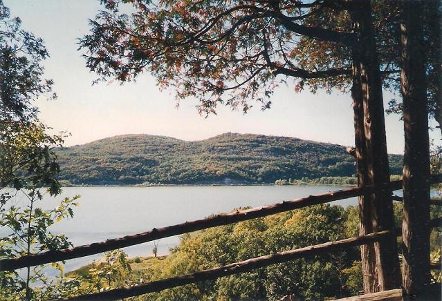
84.48KB
Mount Defiance as seen across Lake Champlain from Mount Independence.
British General John Burgoyne solved his own particular problem by landing his troops and circumventing St. Clair's lines altogether, sending a force of artillery across the outlet to sieze the unoccupied and supposedly unscaleable Mount Defiance; as his artillery commander, General Phillips said, "Where a goat can go, a man can go; and where a man can go, he can drag a gun." Mount Defiance proved to be the key to the entire Ticonderoga position: once in British hands the rest was untenable. A particular weak point was the especially vulnerable bridge of boats that connected the two roughly equal "halves" of St. Clair's position: Fort Ticonderoga and all the land around it; and Mount Independence. Any interruption or destruction of the bridge would effectively divide the already inferior American force, subjecting it to defeat in detail. One can also suspect that this event provided St. Clair with the excuse he needed to abandon the untenable position altogether in the face of overwhelming odds.
Image Insert:
51.48KB
Lake Champlain now divides the states of New York and Vermont; Mount Independence is now perserved and protected as a Vermont State Park. |
| report to moderator |
|
|
James N.
Colonial Militia
USA
Bumppo's Patron since [at least]:
October 24 2007
Status: offline
|
Posted - January 09 2013 : 3:16:13 PM
|
Anyone visiting Fort Ticonderoga today, despite the excellence of the preserved stone fort and outstanding museum collection, will only get an imperfect understanding of what happened here without a drive up Mount Defiance to take in the views of Lakes Champlain and George and all the surrounding landscape stretching as far as the Green Mountains of Vermont; and a journey across the lake to Mount Independence in Vermont. The latter is a slight challenge, involving as it does a ferry ride from the neighboring village of Ticonderoga since there is no bridge, especially now that the nearest one at Crown Point has been condemmed and demolished.
This part of New York and Vermont, though hardly "pristine" and untouched, remained lightly populated and devoted to agriculture when I visited here in 1995 ( and took all the accompanying photos ) and even more recently in 2009. I had previously spent an entire day in the fort and museum on my very first visit in 1992, so devoted most of my time to exploring the outlying area, spending an entire afternoon here on the walking trails of Mount Independence. Unfortunately, at the time of my visit the small visitor center/museum was still under construction.
Image Insert:
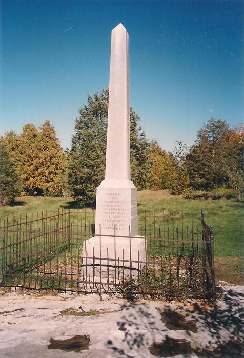
72.87 KB
Now again largely wooded, there are several markers along the trail and this DAR monument to the unknown American dead. One well-known casualty was the grandfather of Trancendentalist author Ralph Waldo Emerson, Rev. William Emerson of Concord, Mass., who had come to minister both spiritually and as a nurse to soldiers returning from Canada and fell victim to the "camp fever" then raging here.
Image Insert:
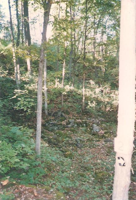
77.99 KB
The Mount Independence site is covered with woods and dotted with small ruins and foundations such as this one, possibly a storehouse or barracks for one of the many artillery positions. It had once been cleared for use as a military installation, but after the Revolution reverted to small farming operations which were in their own turn abandoned.
Image Insert:
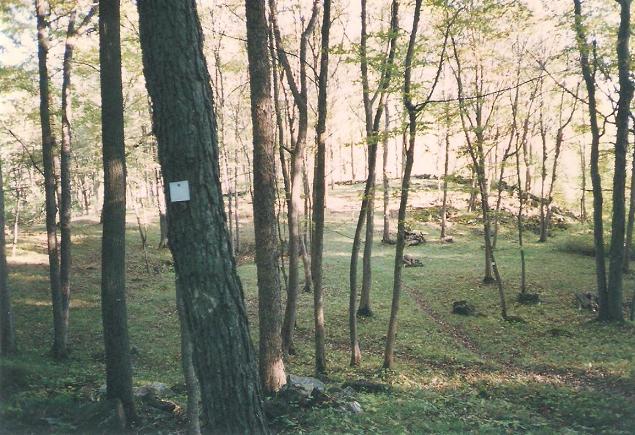
78.94 KB
Along the rise in the background of the above photo can be seen the outline of an extensive battery of artillery which covered the eastern approach to Mount Independence, which despite appearances is not really an island. Its location is separated from the "mainland" only by a creek, which necessitated all-round protection in every direction and furthur stretching the resources of a defender. After its capture by Burgoyne in July, 1777, the British continued to hold the strategic location as a supply depot, improving its defenses with works like the blockhouse whose location is shown below. It was to here that Burgoyne attempted to retreat from Saratoga.
Image Insert:

87.84 KB
Image Insert:
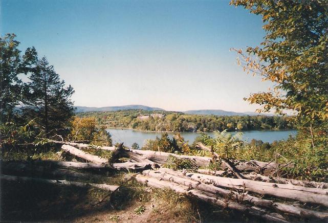
70.46 KB
View of Fort Ticonderoga from Mount Independence's "Horseshoe Battery".
The real importance of Mount Independence is best shown by the photos above and below, in which you can see stone Fort Ticonderoga perched on its bluff across Lake Champlain. These were taken from near the sites of "water batteries" that were intended to defend from an attack from the north, hopefully catching enemy vessels in a crossfire from the fort. Once St. Clair decided to abandon the position here, troops from the fort crossed the pontoon bridge to Mount Independence the night of July 5, 1777, and headed south. Some escaped to Skenesboro by boat, but the main body marched overland through Green Mountains toward more populous southern Vermont. British light infantry and Hessian grenadiers caught up with and severely handled the rear guard under Seth Warner near the hamlet of Hubbardton thereby completing St. Clair's disgrace.
Image Insert:
89.09 KB
A Congressional investigation was called to determine the extent of Arthur St. Clair's responsibility for what was considered widely a fiasco, but he was eventually exonerated, though not without having suffered considerable damage to his reputation. He eventually settled in western Pennsylvania near Fort Ligoner, taking part in another military disaster, this time a defeat at the hands of Chief Little Turtle's Miamis in the post-Revolutionary Northwestern Territory. Of course, the victor, John "Gentleman Johnny" Burgoyne, went on to his own humiliation at the Battles of Saratoga and surrender of his army in October, 1777. Meanwhile, Fort Ticonderoga and Mount Independence settled into decay until the fort was rescued by the Pell family in the following century and much more recently the "mount" developed for historical tourism by the state of Vermont. |
| report to moderator |
|
|
Wilderness Woman
Watcher of the Wood


USA

Bumppo's Patron since [at least]:
November 27 2002
Status: offline
Donating Member |
Posted - January 09 2013 : 5:46:04 PM
|
James, the new bridge at Crown Point has been completed and opened for a little over a year now, so it is possible to get across there.
Lake Champlain Bridge
Fort Ticonderoga will always be my favorite fort and one of the most beautiful places in New York State. That view from Mount Defiance is simply breathtaking. |
"It is more deeply stirring to my blood than any imaginings could possibly have been." |
| report to moderator |
|
|
Wilderness Woman
Watcher of the Wood
USA
Bumppo's Patron since [at least]:
November 27 2002
Status: offline
Donating Member |
Posted - January 09 2013 : 5:56:34 PM
|
I happened to tune in to the show "History Detectives" on PBS last night, and one of the items they were asked to investigate was a nicely engraved powder horn owned by a man in Minnesota. The horn had the name of Captain Richard Cobb on it, along with the date of 1762. The investigation revealed that Capt. Cobb was a participant in the July 8, 1758 Battle of Carillon.
The man who owns the horn now is no relation to the Captain. According to his family's story, it was found by his grandfather about 100 years ago... supposedly just under the surface of the ground on a farm in Minnesota. Highly unlikely that it had been in the ground because the condition is excellent, but how it got to Minnesota remains a mystery.
Here is some more information on Captain. Cobb: Captain Richard Cobb |
"It is more deeply stirring to my blood than any imaginings could possibly have been." |
| report to moderator |
|
| |
Topic |
|
|
|
| The Mohican Board! [Bumppo's Redux!] |
© 1997-2025 - Mohican Press |
|
|
| Current Mohicanland page raised in 0.22 seconds |
 |
|

